GRAND WINNER:
TetraTech - Operating the CZMIL SuperNova in a Remote Micronesian Environment
DATA ACQUISITION AND PROCESSING:
TetraTech - Operating the CZMIL SuperNova in a Remote Micronesian Environment
SURVEYING/FIELD DATA COLLECTION:
NV5 - Albemarle Sound Hydrographic Survey
GIS/IT/REMOTE SENSING ANALYSIS:
Dewberry - NOAA NGS East Coast Historical InSAR Analysis
SMALL PROJECTS:
Aero-Graphics, Inc., Utah's Strawberry River Restoration Project
TECHNOLOGY INNOVATION/LICENSED DATA PRODUCTS:
EagleView - 1-Inch GSD Aerial Imagery
MAPPS Member Choice Award:
TetraTech - Operating the CZMIL SuperNova in a Remote Micronesian Environment
CATEGORY: DATA ACQUISITION & PROCESSING
WINNER:
- NV5 GEOSPATIAL
LOWER COLORADO RIVER BATHYMETRIC SURVEY, A 342 MILE JUGGLING ACT
CATEGORY: SURVEYING/FIELD DATA COLLECTION
WINNER:
- WGI, INC.
BUILDING A HIGH SPEED RAILROAD IN PARADISE
CATEGORY: GIS/IT/REMOTE SENSING ANALYSIS
WINNER:
- NV5 GEOSPATIAL
ANALYZING MONARCH HABITAT WITH REMOTE SENSING, ACHIEVING A BUTTERFLY'S EYE VIEW
CATEGORY: SMALL PROJECTS
WINNERS:
- PRAIRIE ENGINEERS
ELEVATED INSIGHTS: MANNED BS UNMANNED AERIAL LIDAR DATA FOR PRECISION MAPPING - FRANK X SPENCER
LOWER VALLEY WATER DISTRICT - MANHOLE CONDITION ASSESSMENT PROJECT
CATEGORY: TECHNOLOGY INNOVATION/LICENSED DATA PRODUCTS
WINNER:
- EAGLEVIEW
EAGLEVIEW DISASTER RESPONSE PROGRAM
CATEGORY: MEMBERS CHOICE
WINNER:
- AERO-GRAPHICS
SAN-CLEMENTE ISLAND
CATEGORY: GRAND AWARD
WINNER:
- NV5 GEOSPATIAL
LOWER COLORADO RIVER BATHYMETRIC SURVEY, A 342 MILE JUGGLING ACT
A. Data Acquisition and Processing:
Dewberry
Peninsular of Florida Lidar Data Acquisition and Processing Project
B. Surveying/Field Data Collection:
NV5
Lower Laguna Madre, TX - Mapping Hydrography in Extreme Shallows
C. GIS/IT/Remote Sensing Analysis:
Michael Baker
Inland Branch Emergency Cleanup Response Program
D. Small Projects:
SurvTech
Centennial Bridge Data Acquisition and Processing
E. Technology Innovation/Licensed Data Products:
Stantec
Flood Predictor
Membership Choice (tie):
WGI Geospatial
White Sands National Park 2021
Woolpert
Mission-Critical Data Delivery for Geohazard Defense
Grand Award:
Dewberry
Peninsular of Florida Lidar Data Acquisition and Processing Project
2021 Geospatial Products & Services
Excellence Award Winners
TECHNOLOGY INNOVATION/LICENSED DATA PRODUCTS & MEMBERSHIP CHOICE WINNER
Teledyne Optech - CZMIL SuperNova: Programmable Performance, Best in Class Topo-Bathy Lidar
In 2021, Teledyne Geospatial introduced SuperNova, the next generation topo-bathy airborne lidar system. SuperNova is designed for enhanced data collection capability, superior performance and programmable, customized data collection options. The result is increased depth penetration, higher point density and more complete coverage at a higher data accuracy specification. System design was driven by the need for one sensor that can meet a wide range of evolving bathymetric and topographic applications.
DATA ACQUISITION AND PROCESSING WINNER
NV5 Geospatial & GEO1 - The Fire and Water of Pele
The NV5 Geospatial and GEO1 team captured high resolution lidar and imagery over Kīlauea and surrounding areas during the eruptions of 2018, and for follow-up in 2019 for the U.S. Geological Survey, supporting the Hawaiian Volcano Observatory. This complex endeavor resulted in a highly accurate ½ m bare earth DEM of the volcanic landscape and serves as a baseline to model and predict the topography of future lava flows for the safety of residents.
SURVEYING/FIELD DATA COLLECTION WINNER
Michael Baker International, Inc. - Kentucky ADA Compliance Inventory
Michael Baker International partnered with the Kentucky Transportation Cabinet (KYTC) to implement an innovative compliance inventory solution using Mobile LiDAR to locate, measure, and evaluate critical pedestrian infrastructure throughout the Commonwealth to foster increased quality of life and stimulate economic opportunity. Compilation of the statewide Americans with Disability Act (ADA) Transition Plan leveraged MBIs ADA Precision Toolset (ADAPT) to automate evaluation of 34,500 Curb Ramps, 18,600 Crosswalks, 13,100 Intersections and 1,630 miles of Sidewalk.
GIS/IT/REMOTE SENSING ANALYSIS WINNER
Dewberry Engineers, Inc. - Automatic Identification System (AIS) Data Provisioning System and Data Management for the Marine Cadastre Project (Nationwide)
Dewberry helped NOAA and BOEM modernize their public provisioning system that publishes the U.S. Coast Guard’s National Automatic Identification System (AIS) vessel traffic data. Leveraging geospatial and cloud technologies, developing a flexible and scalable tiered architecture and using innovative code deployment, this vanguard system is the template prototype to move NOAA’s resource portfolio to the cloud. Faster self-serve access to AIS data speeds up monitoring and decision support for maritime operators, environmental planners and scientists.
SMALL PROJECTS WINNER
GEO1 - Digitizing Ancient Muir Woods
GEO1 acquired data that will be used to produce an accurate forest inventory and a lasting digital archive
of Muir Woods National Monument. A publicly accessible digital replica of the forest grants anyone the
ability to explore the forest and reveals the possibilities for access and education of our world. The project
also demonstrates the feasibility of large scale lidar acquisition and the value it presents in environmental
research.
GRAND AWARD: PROJECT OF THE YEAR & TECHNOLOGY INNOVATION/LICENSED DATA PRODUCTS WINNER
Vexcel Imaging - UltraCam Osprey 4.1 - The New Standard in Aerial Mapping
Osprey 4.1 is game-changing technology that sets a new standard in aerial mapping systems. The system simultaneously collects photogrammetric-grade PAN/RGB/NIR nadir and RGB oblique imagery—1.1 gigapixels in 0.7 seconds—for a highly-efficient, single system to serve applications ranging from traditional photogrammetry projects to 3D city mapping. It leverages state-of-the-art CMOS sensors, new custom lens kits, new custom electronics, and a new approach to addressing motion blur for data products of unprecedented detail and clarity.

DATA ACQUISITION AND PROCESSING WINNER
WGI - East Selmon Expressway from North Morgan Street to Interstate 75
Selmon expressway included limited access roadways, raised reversible expressways, side roads, intersecting railroads, and multiple on/off ramps. Design survey efforts for widening this roadway corridor posed unique opportunities with regard to Geospatial data collection. WGI applied innovative solutions to integrate Terrestrial Mobile LiDAR (TML) and static LiDAR in challenging environments and developed a robust network to serve the downtown Tampa area for years to come.
SURVEYING/FIELD DATA COLLECTION WINNER
Michael Baker International, Inc. - Pittsburgh Water and Sewer Authority (PWSA) Curb Box Inspection Program
Supporting the Pittsburgh Water and Sewer Authority’s (PWSA) Lead Service Line Replacement Program (LSRP), Michael Baker developed in innovative program to inspect 15,000 curb-boxes over 12-months to identify service lines that may contribute to elevated lead/copper levels in water. Leveraging survey crews, video inspections, and web-enabled GIS, Michael Baker located and catalogued lead lines to prioritize and target PWSA resources for replacement. The solutions has helped the LSLR program replace 8,000+ lead services to date.
GIS/IT/REMOTE SENSING ANALYSIS WINNER
Tetra Tech - Digital Wall Map Solution - Sunoco Pennsylvania Pipeline Project/Mariner East 2
Tetra Tech developed a powerful WebMap application for linear corridor projects that enables project stakeholders to work from the same, approved dataset. It functions as a centralized data management system for all project information by providing direct links to real-time content and data to minimize the risk of using out-of-date information. Data is carried throughout the project life cycle and into daily operations while maintaining continuity and accuracy, making it accessible to all approved personnel.
SMALL PROJECTS WINNER
Geo1 - Acquiring LiDAR of Colombia's Ancient La Mojana Region
In a remote river valley in Colombia, GEO1 acquired data revealing settlement patterns of an ancient civilization. The project, a result of close collaboration with The Earth Archive and the Center of Archaeology and Remote Sensing, sought to demonstrate the versatility of lidar in archaeological research. The data GEO1 provided built upon historical surveys of the area and was integral in transforming perceptions of both ancient civilizations and the use of lidar to study them.
MEMBERSHIP CHOICE WINNER
RIEGL USA - The RIEGL VQ-1560 II: Taking You to New Heights
The RIEGL VQ-1560 II dual channel waveform processing airborne LiDAR scanning system was created to provide increased productivity and is further enhancing customer working environments, point clouds and deliverables. It provides a competitive edge in the marketplace and further demonstrates RIEGL’s customer-centric focus though upgrade capabilities. The cutting-edge system continues to pave the way for overall safety and efficiency within the airborne field and ensures an excellent return on investment to users and their clients.
Thank you to our judges:
Robert Burtch, PS, CP Professor Emeritus of Surveying Engineering, Ferris University
Perry Trunick
Emell Adolphus, Editor-in-Cheif, POB Magazine
GRAND AWARD: PROJECT OF THE YEAR & DATA ACQUISITION AND PROCESSING WINNER
Woolpert/Optimal GEO
Hurricane Maria: Rapid-Response LiDAR Collection
In the wake of 2017's devastating Hurricane Maria, WMR-532 LLC, a joint venture between MAPPS member firms Woolpert and Optimal GEO, collected topographic and bathymetric lidar, digital imagery and hyperspectral imagery data along the Puerto Rican coastline. The team deployed two CZMIL sensors on dual aircraft and performed round-the-clock data processing to support the USNCMP and JALBTCX mission to provide data and analytics for damage assessments, future impact predictions and investments in recovery and resiliency.
TECHNOLOGY INNOVATION/LICENSED DATA PRODUCTS WINNER
WhiteStar Corporation
WhiteStar Legal Mapper
A smart assistant for mapping leases and deeds described by metes and bounds which have traditionally been laboriously mapped by hand. WhiteStar Legal Mapper (or WLM) is also capable of mapping legal descriptions described in terms of subdivision of the public land survey. WLM has the unique capability to take scanned deed or free form text from a database as input, to highlight the compass bearings and distances described, and allow the user to quickly populate and editable data structure from which the final polygon is constructed.
GIS/IT/REMOTE SENSING ANALYSIS WINNER
Aerial Service, Inc.
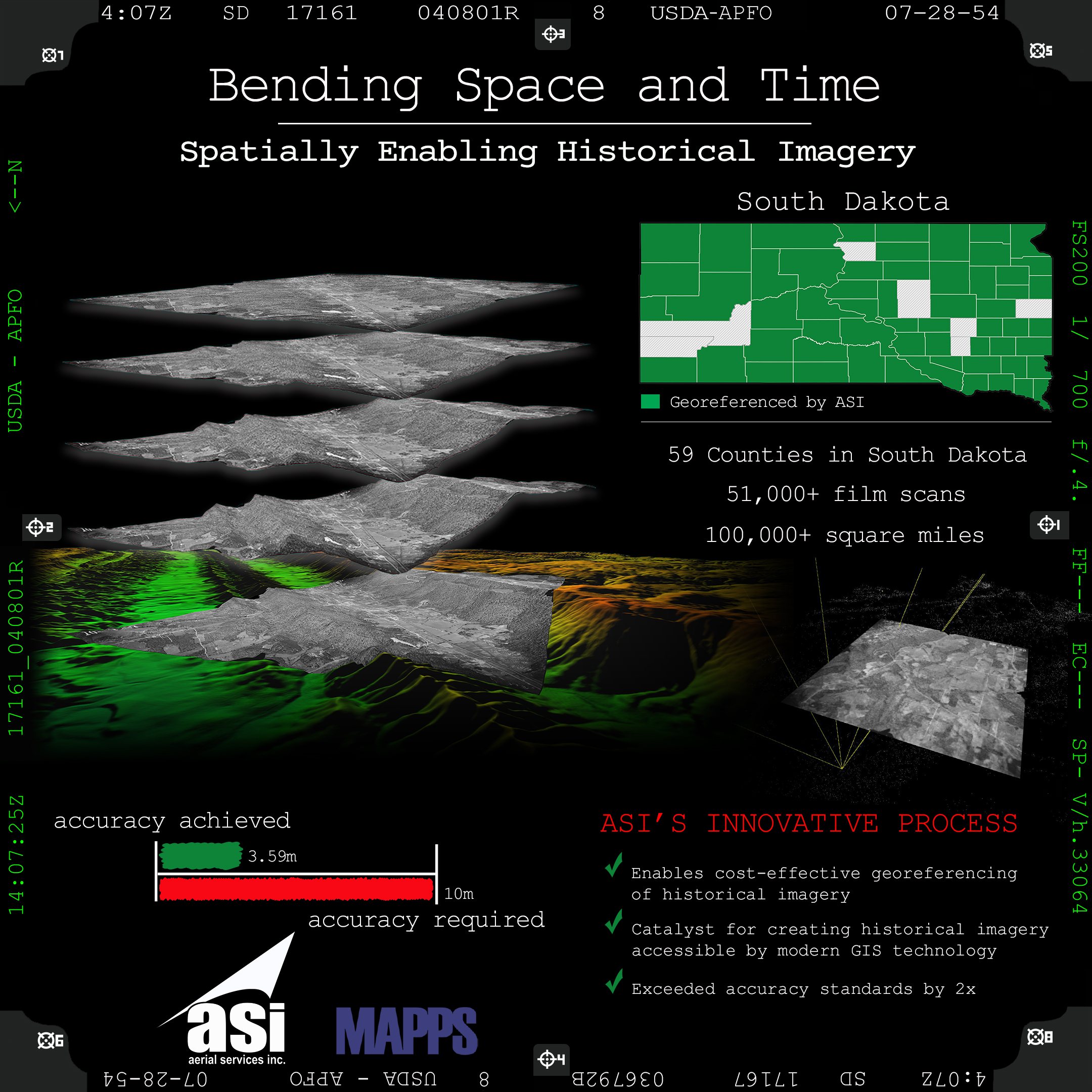
Bending Space and Time
ASI was tasked with georeferencing historical imagery for 59 counties in South Dakota with the goal to produce 59 countywide mosaics. During the process ASI discovered several issues that would lead them to pioneer a new process which enabled cost-effective georeferencing of historical imagery and exceeded accuracy requirements by 2x. With this new process we can gain a better understanding of our land and environmental and economic impacts for a diverse range of applications.
SURVEYING/FIELD DATA COLLECTION WINNER
WGI
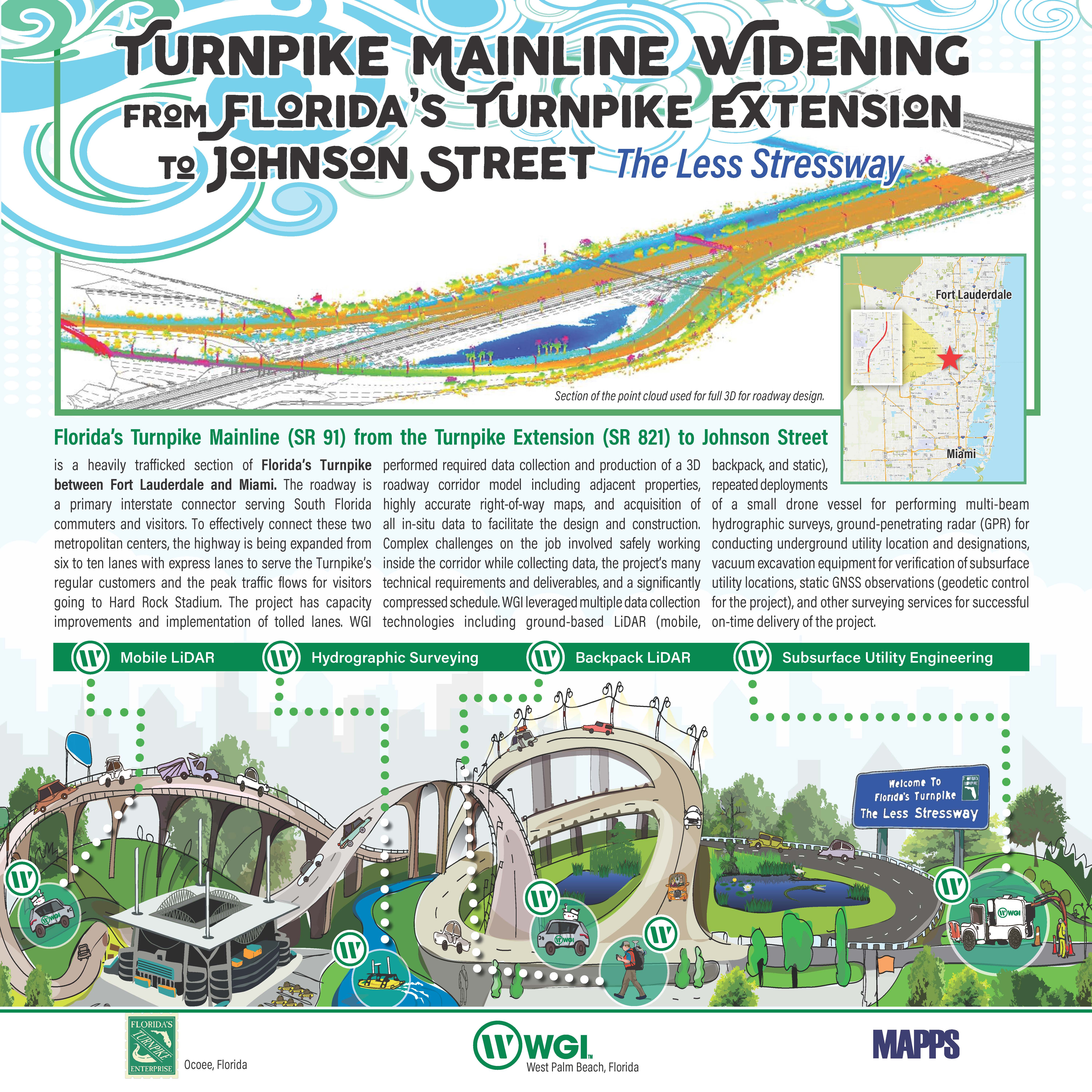
Florida's Turnpike Mainline (SR 91) From Florida's Turnpike Extension (SR 821) to Johnson Street
The Project possesses extraordinary requirements containing complex technical criteria and addresses significant problems associated with a major highway widening project. A portion of the Turnpike's limited-access tollway was designed to expand from six to ten lanes with variable tolled express lanes. Integrated survey products include a geodetic control network, LiDAR systems for 3D data collection, 360-degree imagery, hydrographic surveys, ground-penetrating radar, and electromagnetic surveys designating subsurface utilities to avoid conflicts with the proposed design.
MEMBER'S CHOICE WINNER
RIEGL USA
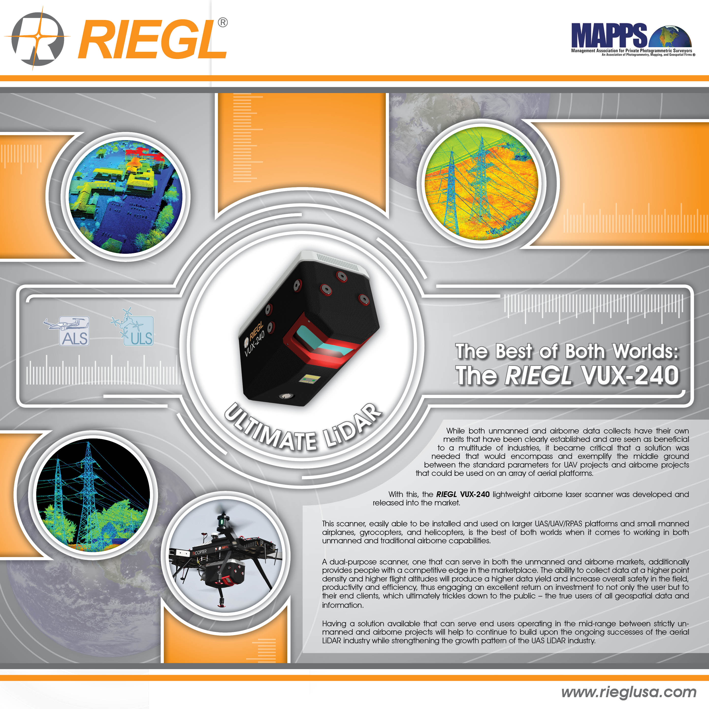
The Best of Both Worlds - The RIEGL VUX-240
Both unmanned and airborne data collects have their own merits that have been clearly established and are highly beneficial to a multitude of industries. However, it became critical that a solution was needed that would encompass the middle ground between UAV projects and airborne projects that could be used on an array of aerial platforms. With this, the RIEGL VUX-240 lightweight airborne laser scanner was developed and released into the market.
Thank you to our judges:
Robert Burtch, PS, CP Professor Emeritus of Surveying Engineering, Ferris University
Perry Trunick, Editor, POB Magazine
Neil Sandler, Publisher, xyHt magazine

GRAND AWARD: PROJECT OF THE YEAR and SURVEYING/FIELD DATA COLLECTION WINNER
Towill, Inc.
San Andreas Pipeline No. 2 (SAPL2) Rehabilitation Study
From inside a nearly 90-year-old pipeline, Towill's surveyors collected the data needed to verify the viability of Kennedy/ Jenks Consultants' recommended approach: repairing the pipeline in place via sliplining. Due to the project's location between two interstate highways and a major shopping mall, traditional excavation would have been prohibitively expensive and disruptive. Sliplining avoids substantial traffic delays and economic impacts to the San Francisco Public Utilities Commission and community.
TECHNOLOGY INNOVATION WINNER
RIEGL
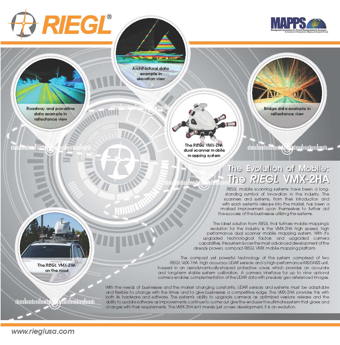
The Evolution of Mobile: The RIEGL VMX-2HA
The latest solution developed by RIEGL that furthers the evolution of mobile mapping for the industry is the VMX-2HA high speed, high performance dual scanner mobile mapping system, introduced at INTERGEO 2017. With its upgraded technological factors and upgraded camera capabilities, this system is now the most advanced development of the already proven, compact RIEGL VMX mobile mapping platform.
PHOTOGRAMMETRY/ELEVATION DATA GENERATION WINNER
Dewberry
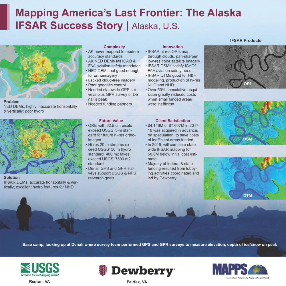
Mapping America's Last Frontier: The Alaska IFSAR Success Story
In 2008, the SDMI contracted with Dewberry to prepare the Alaska DEM Whitepaper, to identify mapping problems and propose solutions.Dewberry determined that Alaska’s surveying and mapping challenges were extremely complex: geodetic control was almost non-existent, cloud-free satellite imagery was not available --even after many years of trying, and the DEM from the National Elevation Dataset (NED) was so poor that satellite imagery didn’t fit the DEM as it should, causing maps to appear as though rivers flowed over mountains rather than through the valleys.
REMOTE SENSING WINNER
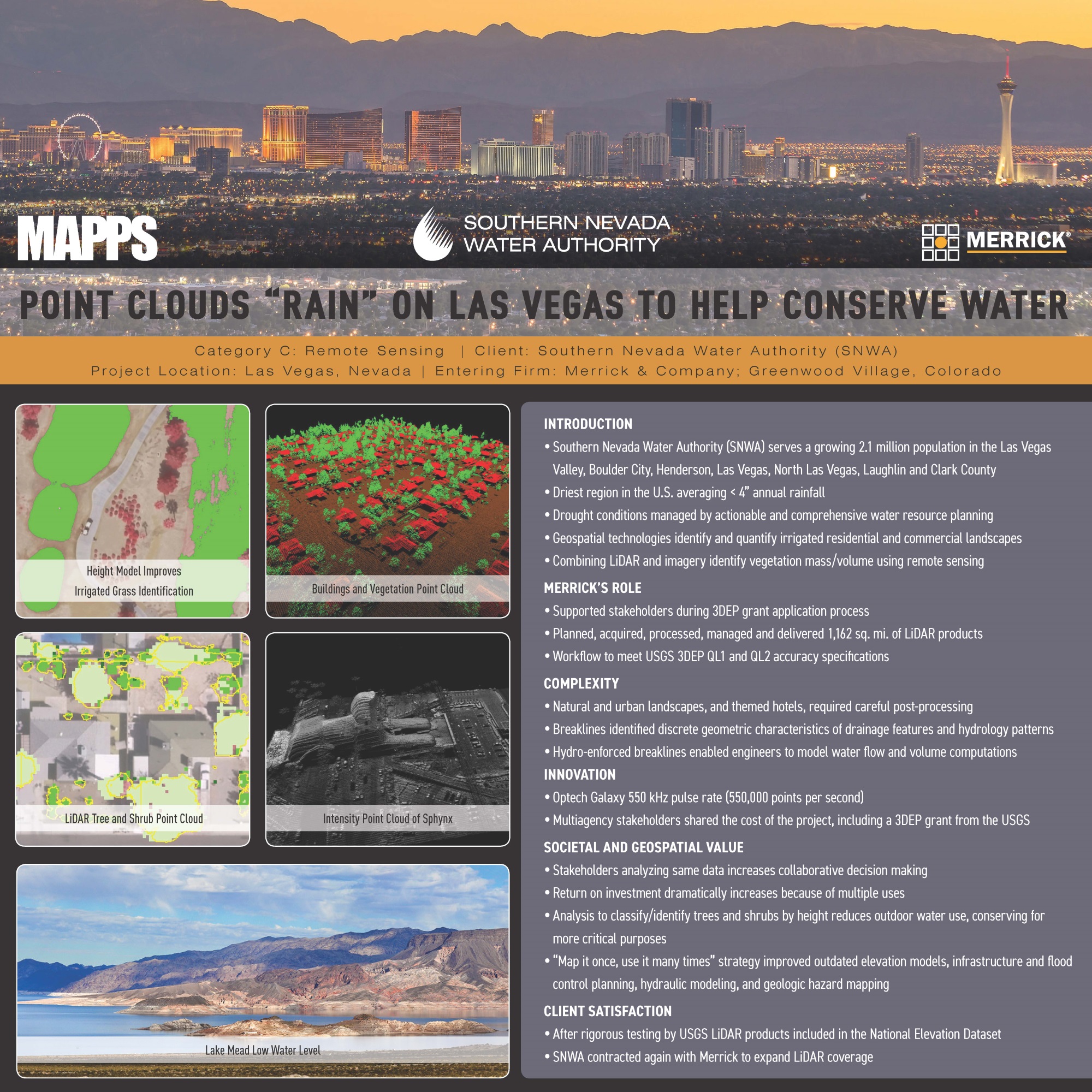
Merrick & Company
Point Clouds "Rain" on Las Vegas To Help Conserve Water
The SNWA was formed in 1991 by a cooperative agreement among seven local water and wastewater agencies. Collectively, the SNWA member agencies serve more than 2.1 million residents in the cities of Boulder City, Henderson, Las Vegas, North Las Vegas, Laughlin and areas of unincorporated Clark County. As the wholesale water provider, the SNWA is responsible for water treatment and delivery, as well as acquiring and managing long-term water resources for Southern Nevada in a region that averages less than 4 inches of rain per year.
AIRBORNE AND SATELLITE DATA ACQUISITION and GIS/IT WINNER
Quantum Spatial, Inc.
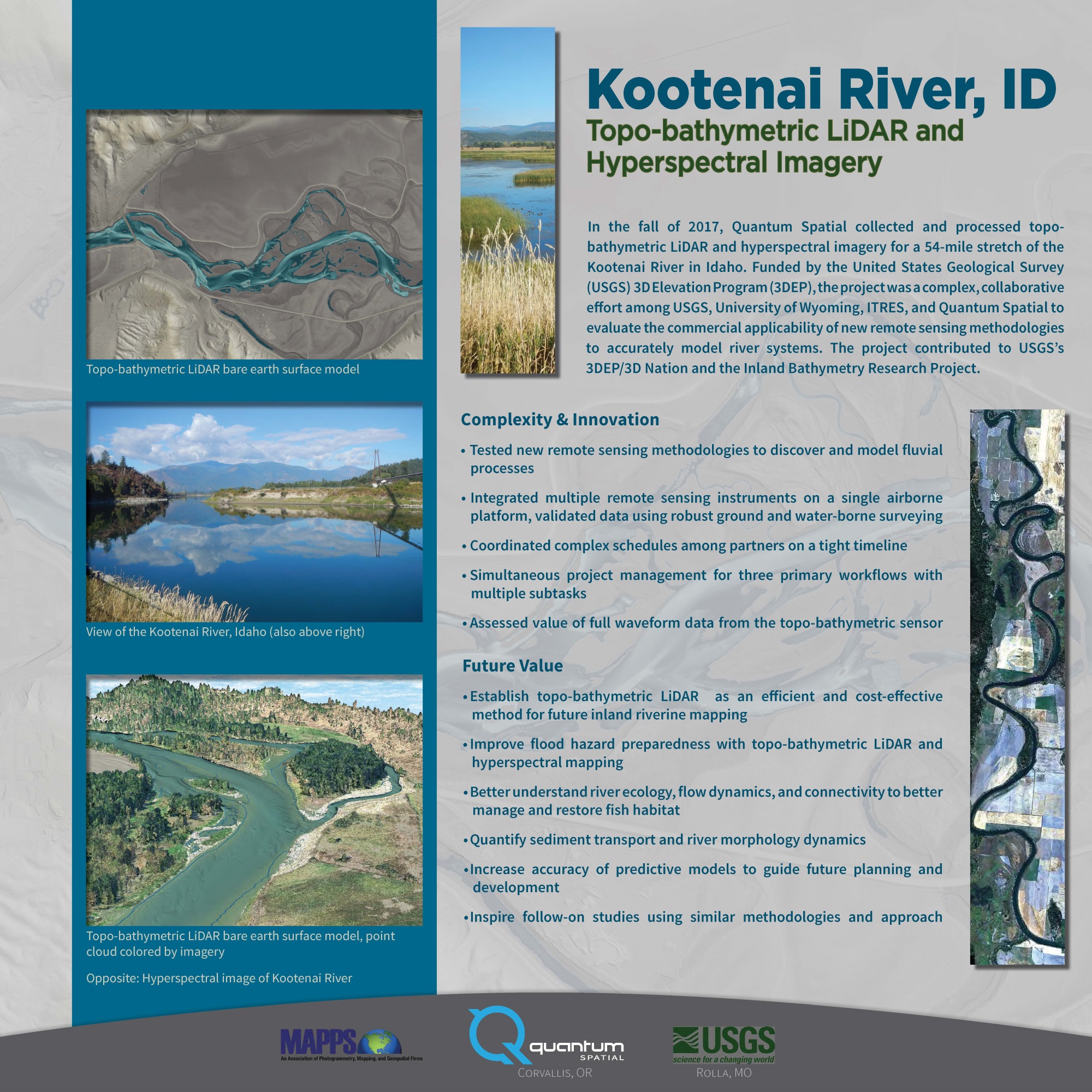
Kootenai River, ID - Topo-bathymetric LiDAR and Hyperspectral Imagery
In the fall of 2017, Quantum Spatial collected and processed topo-bathymetric LiDAR and hyperspectral imagery for a 54-mile stretch of the Kootenai River in Idaho. Funded by the United Stated Geological Survey (USGS) 3D Elevation Program (3DEP), the project was a complex, collaborative effort among USGS, University of Wyoming, ITRES, and Quantum Spatial to evaluate the commercial applicability of new remote sensing methodologies to accurately model river systems. The project contributed to USGS's 3DEP/3D Nation and the Inland Bathymetry Research Project.
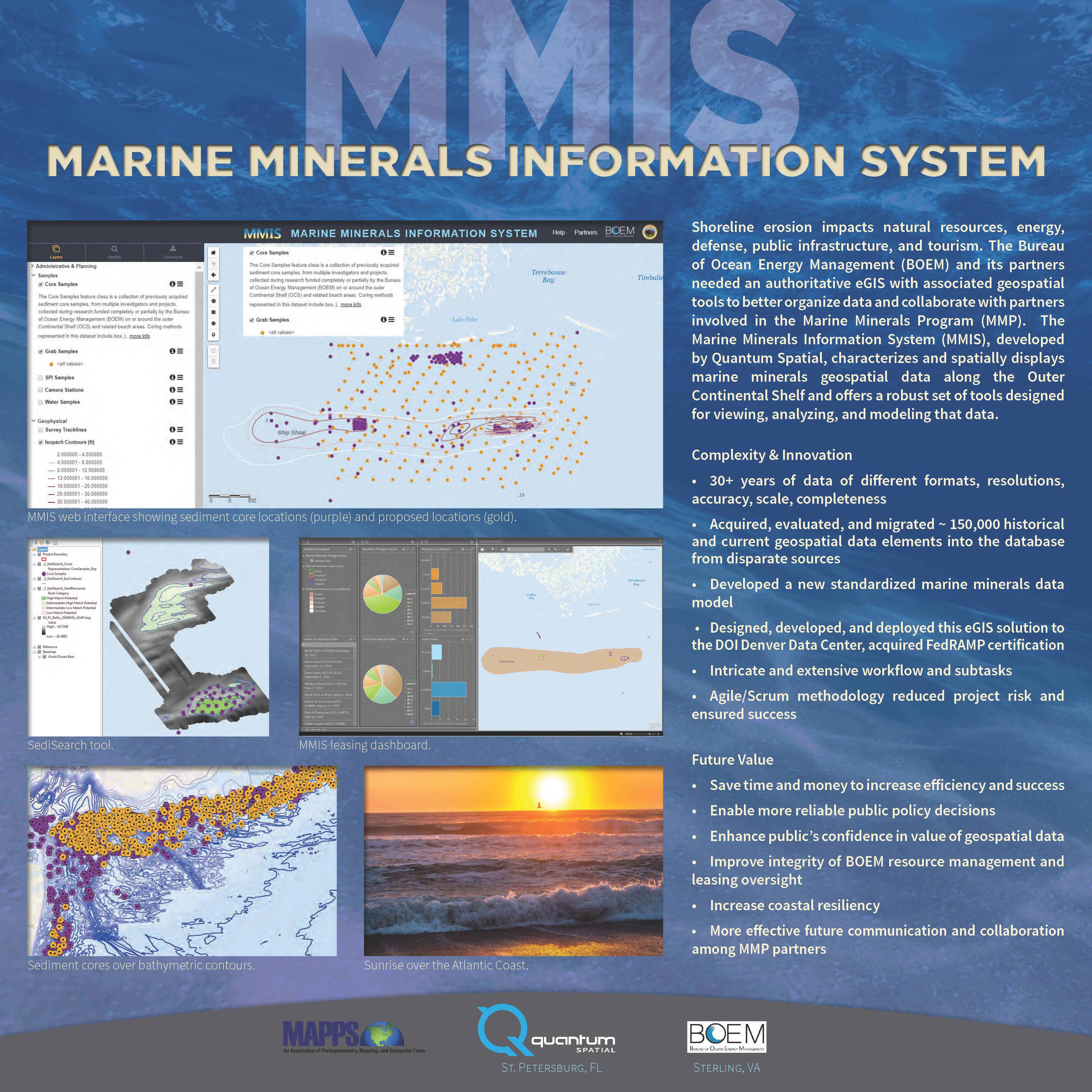
The Marine Minerals Information System (MMIS) is an Enterprise GIS project that stands apart in its unique challenges and complexity, solution ingenuity, originality, and future value to society. Developed by Quantum Spatial, Inc. (QSI) for the Bureau of Ocean Energy Management (BOEM) in collaboration with the National Oceanic and Atmospheric Administration (NOAA) and the Bureau of Safety and Environmental Enforcement (BSEE), this GIS/IT solution is a success story that is worthy of widespread recognition.
MEMBER'S CHOICE WINNER
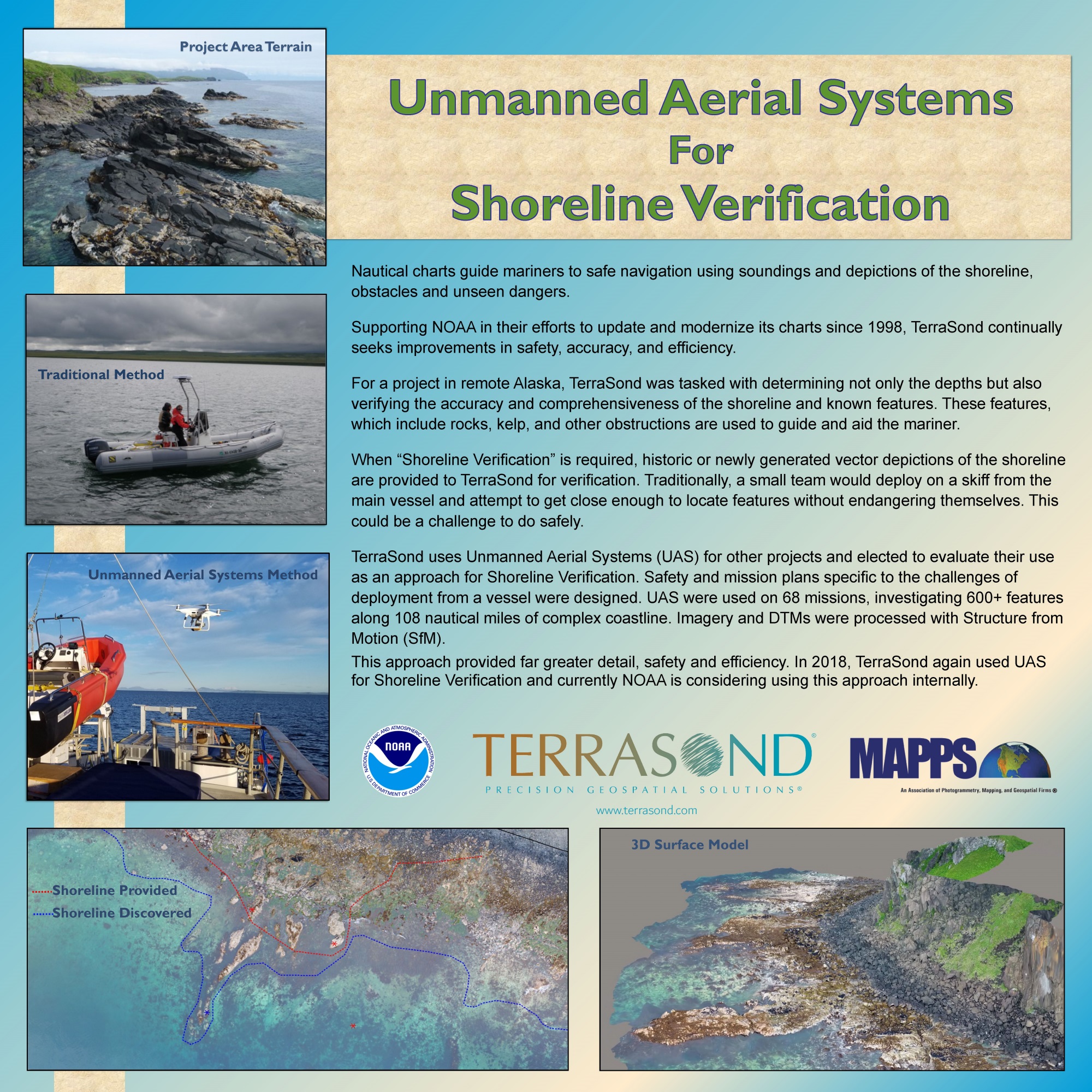
TerraSond Limited
Unmanned Aerial Systems for Shoreline Verification
In continuing support of NOAA’s nautical charting mission, TerraSond was tasked in 2017 with performing a hydrographic survey in Southwest Alaska covering 930 square kilometers of seafloor. NOAA prioritized the area based on the types and frequency of vessel traffic using the area coupled with the outdated and incomplete nature of existing coverage. The project area intersected approximately 108 Nautical Miles of rocky coastline, over which verification and identification of potentially navigationally-significant shoreline features such as rocks, reefs, and ledges were required. Instead of the traditional investigation technique of visiting individual features with a skiff deployed from a larger vessel, TerraSond utilized Unmanned Aerial Systems (UAS) to accomplish the investigations,achieving marked improvements to personnel safety while simultaneously providing a more accurate and comprehensive product and reducing cost.
Thank you to our judges:
Robert Burtch, PS, CP Professor Emeritus of Surveying Engineering, Ferris University
Perry Trunick, Editor, POB Magazine
Neil Sandler, Publisher, xyHt magazine

GRAND AWARD: PROJECT OF THE YEAR and GIS/IT WINNER
Aerial Services, Inc.
Earth on Demand
There were several complexities associated with this project. These include monetizing the project, converting orthophoto mosaics to “web tiles,” making the orthophotos available to the user on the web 24/7, and developing cutting edge image analysis software.
GRAND AWARD: TECHNOLOGY INNOVATION
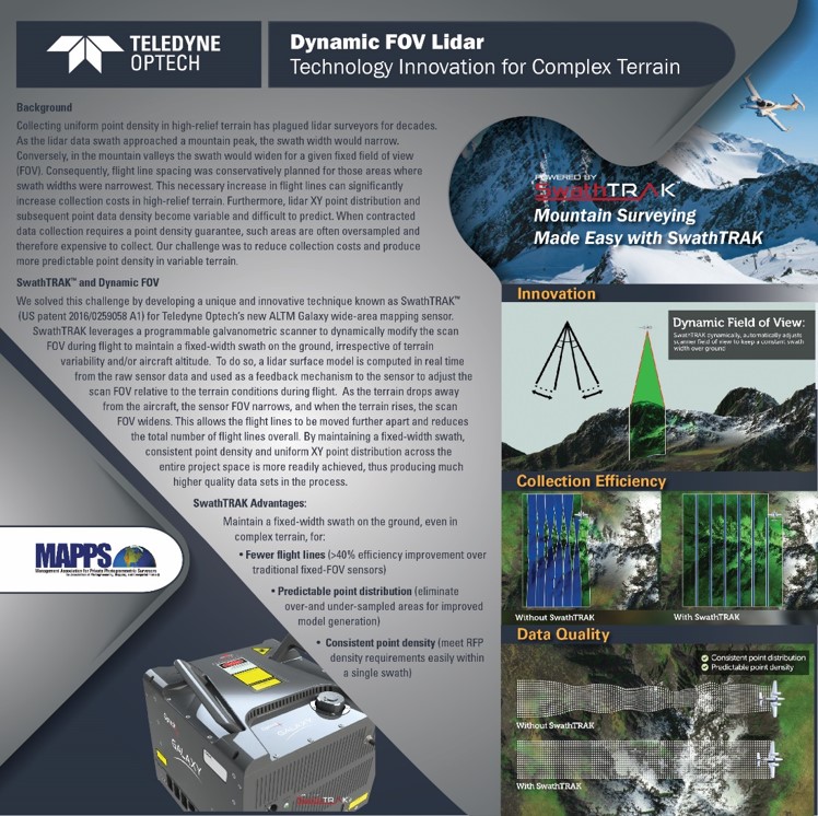
Teledyne Optech
SwathTRAK: Dynamic FOV Lidar for Wide Area Surveying
One of the problems with aerial survey data collection, whether film, lidar or other sensors, has been the changing field-of-view (FOV) over high-relief terrain. Teledyne Optech has solved this problem with SwathTRAK for their ALTM mapping sensor. It works by creating a lidar surface model from the return lidar data in real time. This is then fed back to the sensor to adjust the FOV as the terrain surface changes.
PHOTOGRAMMETRY/ELEVATION DATA GENERATION
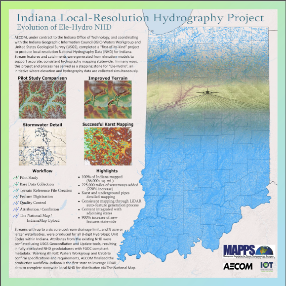
AECOM
Indiana Local-Resolution Hydrography Project, Evolution of Ele-Hydro NHD
This was a massive undertaking where a large amount of lidar data over the whole of Indiana was processed by AECOM. The result was local-resolution National Hydrography Data for the entire state. The future value is in the creation of “Ele-Hydro” where elevation and hydrography data are collected at the same time.
REMOTE SENSING
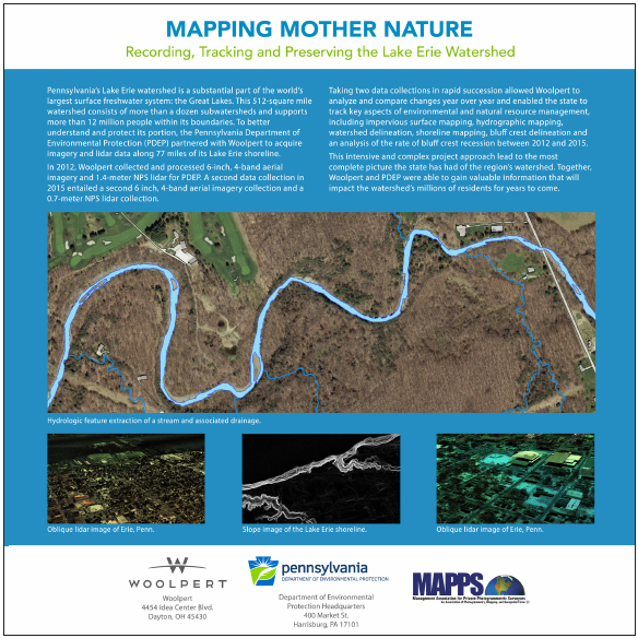
Woolpert
Mapping Mother Nature: Recording, Tracking and Preserving the Lake Erie Watershed
Woolpert used a hyperspectral data cube at a 1-meter resolution which was fused with lidar data. This was then compared to historic data for change detection along 77 miles of Lake Erie shoreline. The watershed consisted of over 40 major sub-basins which created a big challenge in the mapping of the watershed.

AIRBORNE AND SATELLITE DATA ACQUISITION
Merrick & Company
New Heights to Railroad Safety – NE Illinois PTC System Integrator
This project utilized existing technology, helicopter and track-side lidar, to implement Positive Train Control (PTC) as mandated by the Federal government. This is an important project for our aging train network that should eventually lead to greater safety for the traveling public. The consequences of our current system have come to the fore recently with train accidents in Hoboken, NJ, and Brooklyn, NY.
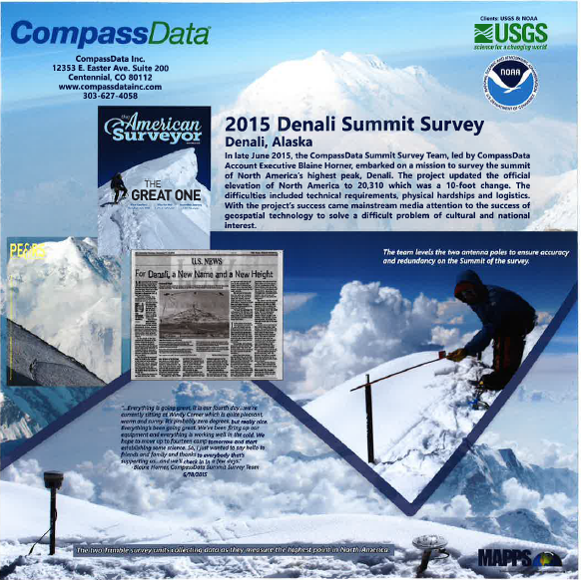
SURVEYING AND FIELD DATA COLLECTION
CompassData
2015 Denali Summit Survey
Denali is the largest mountain peak in North America and, understandably, presents very unique and dangerous weather challenges. These challenges included the effects of extreme cold on the equipment and the long GPS baselines. In a year where less than 60% of the summit attempts were successful, this team had to make 2 ascents, first to deploy the equipment and then to retrieve it. Moreover, this project brought a lot of good PR to the surveying and geospatial services community.
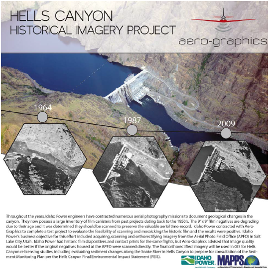
SMALL PROJECTS
Aero-Graphics
Hells Canyon Historical Imagery
This project involved scanning historic aerial photos which were then orthorectified. The integration of old films was complex because control was not always available. This required painstaking work by Aero-Graphics to creatively integrate this unreliable data. The project provides a useful overview for evaluating new projects in the Hells Canyon area.
Thank you to our judges:
Robert Burtch, PS, CP Professor Emeritus of Surveying Engineering, Ferris University
Donn Dears, Author, Nothing to Fear
Perry Trunick, Editor, POB Magazine
Leonard C. Gilroy, Director of Government Reform, Reason Foundation
Karen Kerrigan, President & CEO, Small Business & Entrepreneurship
Neil Sandler, Publisher, xyHt magazine